| ||||
|
| ||||
|
GASPAR
DE PORTOLA
 Lived:
about 1723-1786
Lived:
about 1723-1786
Explored California in: 1769-1770
Exploring for: Spain
Explored: by land from Baja California to San Francisco Bay
Portolá was the military commander of the Sacred Expedition, the first Spanish exploration by land from Baja (Lower) California to San Francisco Bay.
EARLY HISTORY
Gaspar de Portolá was born in
the Catalonia region of northeastern
Portolá came to New Spain (
BACKGROUND
In 1769 the Spanish government, fearing that the Russians would move down from Alaska into Alta (Upper) California, decided to found some settlements there. Portolá volunteered to lead the expedition, later known as the Sacred Expedition.
While part of the expedition went by sea, Portolá went by land. With him was Father Junípero Serra, the Franciscan priest who would establish the mission-settlements in Alta California. Portolá would establish the military bases, called presidios.
PORTOLA’S JOURNEY
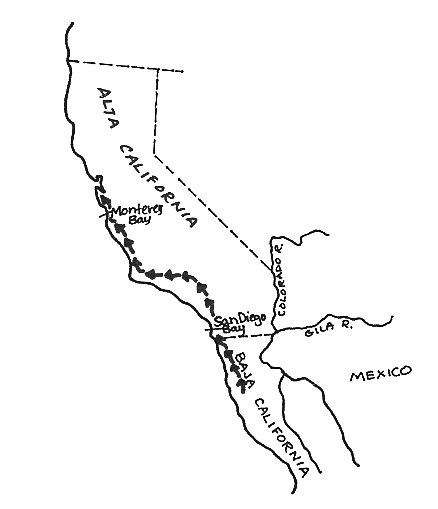
Portolá and Serra left Baja California on May 15, 1769, with a group of 28 soldiers, Baja Indians, and muleteers. Traveling on foot and horseback, they arrived at San Diego Bay the end of June. There they met the rest of the land expedition and the two ships. The journey had been a hard one, especially for those on the ships. Many had died of scurvy, and many more were ill.
Portolá raised the Spanish flag at the site chosen for the San Diego Presidio. His directions had been to establish two settlements, one at San Diego and the other at Monterey. Though there were few able-bodied men, Portolá left San Diego on July 14, with Sgt. José Oretega (the scout), Lt. Fernando Rivera, Lt. Pedro Fages, cartographer Miguel Costansó, Father Crespí, those soldiers fit to travel, and 100 mules carrying supplies. There were 63 people in all.
As scout, it was Sgt. Ortega’s job to go ahead of the group, searching out the best route for them to travel. This was a most important task. He looked for water and for camping places. He also watched for signs of danger.
Near a river they felt several
earthquakes. They named the river Río de los Temblores (now the Santa
Ana River). Four days later Father Crespí named the Río de Porciúncula
(now the Los Angeles River). It was August 2, the feast day of Our Lady
the Queen of the Angels, whose shrine was at Porciuncula in
Portolá’s route north followed fairly close to what became El Camino Real (The King’s Road) and Highway 101. They met Indians along the way. Father Crespi’s diary describes with admiration the plank canoes of the Chumash. The Chumash gave them gifts of fish, seeds, and acorn mash. The explorers gave the Indians beads and ribbons.
Near what is now San Luis Obispo
they saw grizzly bears and named the area
When they reached the Salinas River they followed it to the sea, thinking it was the Carmel River described by Sebastián Vizcaíno in 1602. The coastline here did not fit Vizcaíno’s description. Though they saw a large bay, it was not the sheltered harbor of Vizcaíno’s report.
It had taken 78 days of travel to reach this point, about 410 miles from San Diego. It was October, and the weather was wet and cold. Thinking they had not yet reached Monterey Bay, Portolá pushed on north again on October 7.
Three weeks later they were at Point San Pedro (on what is now the San Francisco Peninsula). Portolá looked across the Gulf of the Farallons towards Point Reyes and realized that they must have missed Monterey Bay. Portolá’s chief scout, Sgt. José Ortega, told him of a large body of water to the east of them (San Francisco Bay), but Portolá gave it little attention.
On November 11 Portolá headed south again. They stopped at Monterey Bay from November 28 to December 11. Though he still did not think it was Monterey Bay, Portolá set up a large wooden cross on a hill near the beach. On it he carved a message about their expedition.
By now many of the men were ill and food was scarce. They had to eat some of their mules as they struggled back to San Diego. They traded clothing to Indians in exchange for food. They got back to San Diego on January 24, 1770. They had been on the road for more than six months and had traveled about 1,200 miles. Portolá was unhappy, thinking that he had failed in his mission.
In San Diego Bay was the San Carlos ship with Captain Vila. Vila convinced Portolá that the bay he found was indeed Monterey Bay. On April 17, 1770, Portolá started back north again with Father Crespí and 19 soldiers under the command of Lt. Fages. At the same time he sent the San Antonio by sea, captained by Juan Peréz, with Father Serra, Miguel Costansó, and supplies.
The weather was better this time and Portolá arrived at Monterey Bay in 32 days. He began construction on the presidio and mission. The cross that he had left on the beach the year before was still standing, now surrounded by Indian arrows and shellfish.
WHAT HE ACCOMPLISHED
Portolá led the first extensive exploration by land from San Diego to San Francisco, naming many points along the way. He founded the first two Spanish presidios (San Diego and Monterey). His party included the first Europeans to report on seeing San Francisco Bay (though they did not name it).
LATER YEARS
Portolá left Lt. Fages in charge of the Monterey presidio on July 9, 1770, and took a ship bound for Mexico. He arrived there on August 1, and did not visit California again.